Regional Water Studies
In response to concerns about the urgency and possible lack of transparency regarding the IEDC-led water study conducted by Intera in Tippecanoe County and concerns raised by local governmental leaders and citizens, Indiana Governor Eric Holcomb halted the IEDC study. The governor then asked the Indiana Finance Authority (IFA), which had led regional water studies in other parts of the state, to lead much larger regional studies along the Wabash.
LATEST Studies
Noting the need to understand resources along the Wabash and their interconnectivity, the IFA conducted two new regional water studies simultaneously, from the Spring of 2024 through the end of the year.
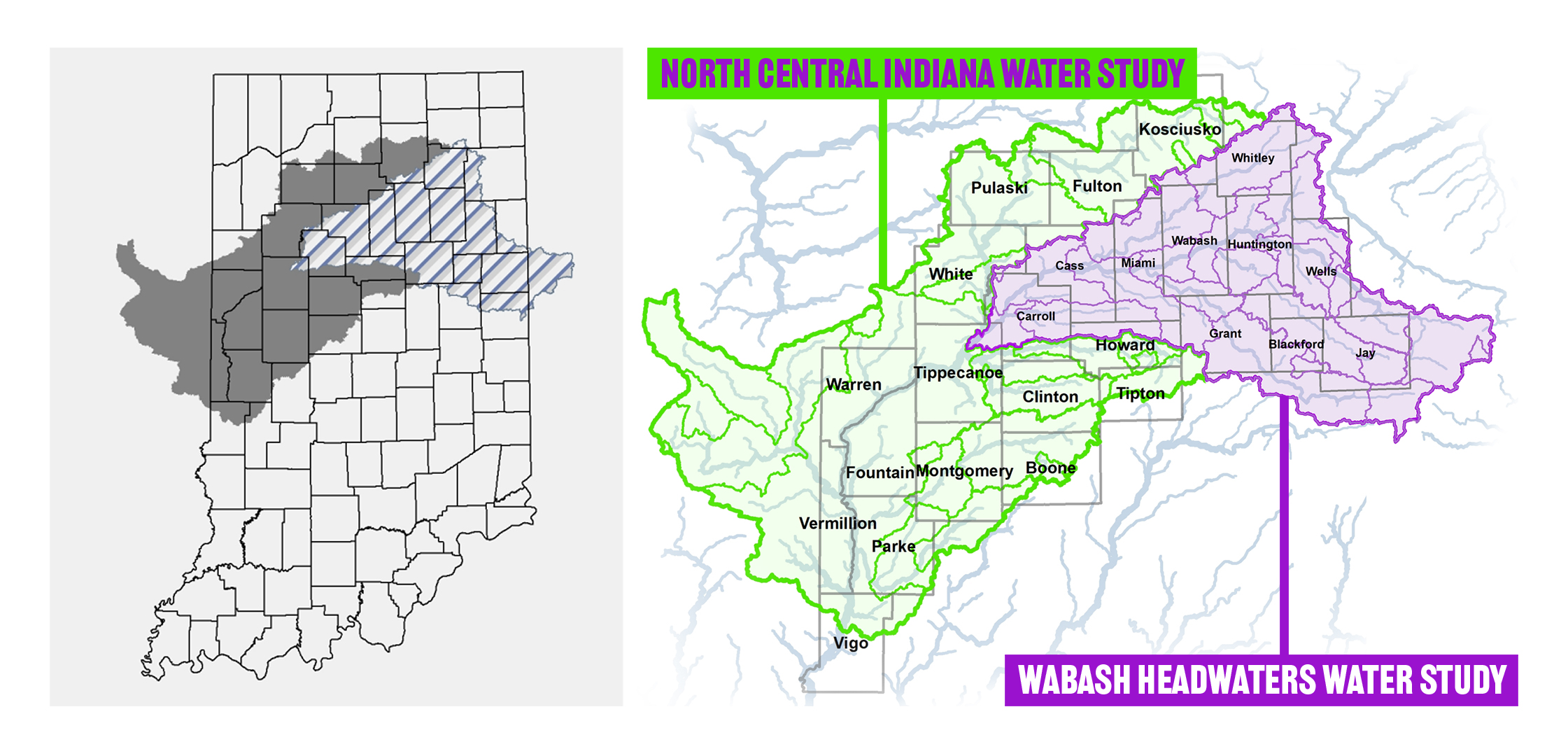
The 15-county North-Central region includes Tippecanoe County and points west and south along the Wabash. The 10-county Wabash Headwaters region stretches from western Tippecanoe County east to the Indiana state line and beyond.
To date, the IFA has been responsive and transparent regarding its goals and objectives, its process, and, as it did in its previous studies across the state, its desire to gather scientific data regarding the region’s water resources and their quality, quantity, and expected viability for the next 50 years.

Frequently Asked Questions
The Intera Study is a pump test conducted by Intera, an environmental and water resource consulting firm, on behalf of the Indiana Economic Development Corporation (IEDC). The pump test was focused on the Wabash River alluvial aquifer system in Tippecanoe County, just west of Lafayette. The IEDC funded it, as the quasi-state entity was working to recruit large-scale water users to the LEAP (Limitless Exploration/Advance Pace) District in Lebanon, Indiana. The IEDC said the goal of the Intera study was to analyze the scale of water availability in Tippecanoe County to assist in the development of LEAP Lebanon and address future water resource challenges facing central Indiana and the Indianapolis metro area. The IEDC publicly suggested the study would assess the possible future impacts on Greater Lafayette’s water supply.
The primary goal of the IFA’s North Central Indiana Regional Water Study was to improve the understanding of estimated future groundwater and surface water demand and availability within the public water utility sector so that a gap analysis can be conducted. The questions the study sought to answer included: How much water is currently available? Will there be enough water to meet the 50-year Public Water Supply needs?
The study examined the 50-year demand and supply availability in the watershed, which includes parts of Boone, Clinton, Fountain, Fulton, Howard, Kosciusko, Montgomery, Parke, Pulaski, Tippecanoe, Tipton, Vermillion, Vigo, Warren, and White counties.
It is important to note, this study is not a continuation of any water-related investigations that may have been conducted in the region. However, all relevant data will be evaluated for inclusion in the IFA’s final report.
The primary goal of the IFA’s Wabash Headwaters Regional Water Study was to improve the understanding of estimated future groundwater and surface water demand and availability within the public water utility sector so that a gap analysis can be conducted. The questions the study sought to answer include: How much water is currently available? Will there be enough water to meet the 50-year Public Water Supply needs?
The Study examined the 50-year demand and supply availability in the watershed, which includes parts of Blackford, Carroll, Cass, Grant, Howard, Huntington, Jay, Miami, Wabash, Wells, and Whitley counties.
It is important to note, this study is not a continuation of any water-related investigations that may have been conducted in the region. However, all relevant data will be evaluated for inclusion in the IFA’s final report.
The regional water studies commissioned by the Indiana Finance Authority (IFA) are designed to provide state leaders with critical data and insights into Indiana’s water resources. While more study is needed, the findings from these studies will help equip decision-makers with the necessary information to make informed choices regarding managing and utilizing water resources across the state. This includes planning for sustainable water supply, addressing future water demands, and developing infrastructure projects. These studies aim to ensure that water resource decisions are based on sound scientific data and contribute to the long-term viability and growth of the state.
Glossary of Commonly Used Terms
Aquifer
An underground layer of permeable rock, gravel, or sand that holds water, allowing it to flow through and be extracted for use.
Right-of-way (ROW)
The legal right to pass through or use a specific strip of land for the construction and maintenance of infrastructure.
Watershed
A geographic area of land where all surface water drains to a common outlet, such as a river, lake, or ocean. It includes the surrounding land and the network of rivers, streams, and water bodies within it.
